SoCal Forecast
Updated most Sundays, Tuesdays, and Thursdays
Tuesday 7/28/26 6:00 AM
By Nathan Cool
Surf Charts for SoCal
Rincon | Ventura, C-St. | County Line | Malibu | Hermosa | Huntington BeachTrestles | Old Mans | Oceanside | Beacons | Sunset Cliffs
Subscribe to be notified:
Get notified when this report is updated.
At a glance:
Today (Tuesday the 28th) we have a fair amount of southern hemisphere ground swell in SoCal with background NW wind swell. Substantial swell from Hurricane Genevieve will fill later today, peaking over the next couple days. And light to moderate southern hemisphere ground swells are being watched for the 8th-9th and 13th. Condition-wise: more heat on the way but relief in sight; winds stay moderate for the most part; a tidal swing is underway; water temps remain warm; and advisories are in effect.
|
|
|
Current Conditions:
Early this morning, periods were primarily running 18 seconds from 195-210° and 8 seconds from 310°.
Most south facing breaks were running chest to at times head high. Direct west facing breaks were mostly waist to chest, bigger at SW exposed spots. SE swell should increase later today (more on that in a sec).
Buoys in the outer waters were running 9'. Nearshore buoys were running 2-3' (south facing) to 4.5' (west facing), with southern hemi energy measuring up to 3' on the spectrum.
Tide levels are swinging wide as we approach a Full Moon Wednesday the 29th. Today we have a -0.5' low around 4:30 AM, a 4' high around 10:30 AM, a 2.5' low around 3:00 PM, and a 6' high around 9:00 PM.
Water temps were mostly 72-75° around much of SD, OC, and LA. In VC, Channel Islands Harbor reported 71° last night. In SB, Stearns Wharf reported 71° this morning.
Hazard Warnings: Risks for rip currents, sneaker waves, high consistency, alongshore currents, and coastal flooding will be elevated for the remainder of the week from southern hemisphere ground swells, more so once swell from Genevieve arrives (see timing below). The NWS has issued warnings as well for SB, VC, and LA here and OC and SD here.
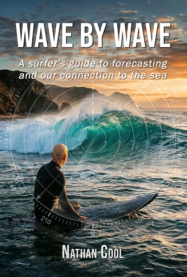
New Release: Wave By Wave
Take a journey into the hidden forces behind every swell and the ocean's connection to our human experience. After more than 30 years of tracking storms across the Pacific, Nathan Cool's latest book, Wave By Wave, takes you beyond basic swell prediction and into the deeper story behind the surf. From distant, powerful storms to the moment a wave breaks, you'll learn how to read the ocean with confidence and discover how these rhythmic forces bind us to the sea with a deeper sense of meaning.
Get the Book
Surf Forecast:
Today (Tuesday the 28th) there is some background NW wind swell in the mix as outer water winds near Pt. Conception and the Channel Islands have been blowing over 25 mph consistently for the past 24 hours. The dominant energy this morning though is from this system that peaked near New Zealand about nine days ago (model generated by XyGrib from NFCENS data):

That swell will continue to fill in today, peaking Wednesday the 29th. On its own, that would produce chest to head high sets Wednesday. But later today into Wednesday the 29th we'll see the first signs of swell from Genevieve, seen here from space yesterday afternoon (image from NOAA GOES):

Genevieve's winds reached 150 mph at one point yesterday, whipping up seas well over 35'. However, she was just entering our swell window then and is turning more west than northwest. The initial swell later today will be angled from a difficult 160° (page 45), so most south facing breaks will see lesser, diffracted energy initially (page 77). The westerly turn also means we'll see a fair amount of loss from her angular spread (page 52), with her trajectory (not swell angle) being about 50° away from SoCal — greater over the next couple days as Genevieve continues westward.
Running the numbers last night and again this morning, we should see 160° energy from Genevieve later today, likely mid to late afternoon. For breaks that can work such a steep SE angle, sets in the 2-3' overhead range are expected. Bear in mind that southern hemi ground swell will build later today (peaking Wednesday the 29th) so sets upwards of head high will be present later today for other south facing breaks, which is the size to expect at south facing breaks that can't work a SE angle.
Wednesday the 29th should see Genevieve's swell fill in better as the swell angle improves to 165-170°. Size should run 2-4' overhead at many south facing breaks with max periods running 17 seconds. Other, shorter periods will be in the mix making for high consistency (page 153). It is possible that some pluses could run upwards of DOH at standouts that can work a SE angle.
Thursday the 30th should see Genevieve's swell angle improve to 180° with most south facing breaks running 2-4' overhead. There is still potential for bigger waves at times at standouts, especially since the 180° swell angle can amplify refraction through the San Diego Trough for some spots (see page 111 in Wave by Wave). So it's possible that some standouts could see sets upwards of DOH on Thursday.
Friday the 31st should see sets running 1-2' overhead at south facing breaks as that's the last prime position for Genevieve's swell. Size should drop to around head high Saturday the 1st.
Saturday the 2nd, as hurricane swell backs down to chest high or so, we'll likely see a slight increase in NW wind swell from a trough of low pressure pushing south toward SoCal. Wind swell would put most west facing breaks in chest max waves (by the looks of things today).
Monday the 3rd through Friday the 7th look like small days in the SoCal surf zone. Tropical cyclones are absent on the long range models and there was a temporary lapse in southern hemisphere activity. Most ways will likely run waist high or so from the 3rd through the 7th.
Saturday the 8th into Sunday the 9th will likely see SW ground swell from this system heading north off Antarctica on the 3-day models (model generated by XyGrib from NFCENS data):

With 25'+ seas from that distance and course, SoCal's south facing breaks are looking at waist to chest high sets, angled from 195° and periods 16 seconds.
Thursday the 13th is the next southern hemi on my charts this morning from this activity off New Zealand on the 6-day models (model generated by XyGrib from NFCENS data):

So far, that holds potential for chest high waves at south facing breaks, angled from 215-220° and periods 16-17 seconds. Models aren't in agreement yet on this one and it's still a ways out on the long range.
And last up, before getting to weather and winds, in case you missed it from my Sunday report I wanted to keep you abreast on the seasonal outlook based on recent developments. Frist, recent model runs continue to trend high for El Niño becoming quite strong in a few months (model from NOAA CPC)

The thick dashed line shows the model mean, topping out around 2.5°C anomalous by the winter. By comparison, the El Niño of 2015-16 measured 2.6°C, and the 1997-98 was 2.4°C. So this year's El Niño should be right up there with those exceptionally active events. This time around though we're also dealing with Marine Heat Waves (MHV); in particular, one sitting off Baja and SoCal (model from NOAA Coral Reef Watch):

That mass of warm water off Baja is essentially merging with the warm waters in the El Niño zones, which is something new this time around. That particular marine heat wave is thought to be caused from a lack of cold water upwelling from fewer northerly wind events this past year. Models right now show that marine heat wave weakening after the winter, but tracking these warm-water events is still in its infancy. Still, there is one other thing that could affect the sustainability of the marine heat waves and El Niño: The PDO (page 159).
Currently, the PDO is in a negative state. Being out of phase with this year's El Niño means there could be a lack of long-term support for warming waters. However, the PDO has warmed 50% since this time last year, which raises another question: when will the PDO shift to a warm phase to support higher El Niño frequency? The PDO's last warm cycle ended around 2019 after lasting five years — half as long as usual. The PDO has been in a cool phase since, putting us at year 6 right now. Since this climate cycle spans decades (something I talk about in Surf, Flood, Fire & Mud), we would think that we'd have at least a few more years before the PDO flips the script to support warming trends. However, in the past few decades, PDO cycles have spanned 4-7 years, which increases the probability for a warming cycle to start soon. If the PDO can trend warmer later this year or early next year, then we're looking at higher probability of the marine heat waves continuing and, more importantly, more frequent — or longer sustained — El Niños.
Right now there are numerous variables at play, some of which are throwing curveballs at seasonal forecasts. There is a lot to monitor, but as long as I have your support then I can continue to keep an eye on the Pacific to keep you posted. Please remember this report is funded by reader donations and your help is crucial to keep it alive (see why here).
|
|
|
Here's a brief look at how the next few days are breaking down so far:
Wednesday the 29th should run 2-4' overhead at breaks able to work a SE angle (165-170deg;), but head high at south facing breaks that lack good SE exposure. Rogue waves upwards of DOH are possible at standouts.
Thursday the 30th should run 2-4' overhead at most south facing breaks. Rogue waves are once again possible.
Friday the 31st looks about 1-2' overhead at south facing breaks.
Saturday the 1st looks head high to slightly overhead at south facing breaks in the early morning with swell fading later in the day.
Sunday the 2nd looks about chest high at most breaks.
Monday the 3rd, so far, looks about waist to chest max at most spots.
Tuesday the 4th, so far, looks about waist high at most spots.
Wednesday the 5th, so far, looks about waist high at most spots.
Thursday the 6th, so far, looks about waist high at most spots.
Friday the 7th, so far, looks about waist high at most spots.
Saturday the 8th may see southern hemisphere swell start to fill in, likely running waist to chest at south facing spots.
Sunday the 9th could see southern hemisphere ground swell running upwards of chest high at south facing breaks.
Weather Outlook:
Today (Tuesday the 28th) high pressure over the American West, centered primarily over the 4-Corners region, is the main factor in SoCal weather for the next couple weeks. Right now, that high is fairly strong at 596dm and should pretty much stay that way through Thursday the 30th. But on Friday the 31st that high strengthens to an extremely strong 600dm, signaling extreme heat for SoCal (inland, of course, more than the beaches). That high should remain put Saturday the 1st but then slowly weaken Sunday the 2nd. By Monday the 3rd the high should weaken to 597dm, and then 595dm Tuesday the 4th. This is when a trough of low pressure pushes south from storm activity located up in Canada, giving us modest relief from that pressure cooker high. High pressure should temporarily gain strength at some point during the second half of next week, but then greatly weaken by the weekend of the 8th as the high also moves to the east, away from our area.
All the while, the inversion remains moderate as surface air temps are quite warm at the beaches and over the coastal waters from water temps being warmer than normal around SoCal. This should keep marine layer in check with timely burn-offs through the forecast.
Taking all of this into account, here's how I'm calling SoCal beach weather for the next few days:
Today (Tuesday the 28th) should see an early burn-off and max beach temps in the mid 70s.
Wednesday the 29th should see AM marine layer with a burn-off midmorning and max beach temps in the mid 70s.
Thursday the 30th should see AM marine layer with a burn-off mid to late morning and max beach temps in the mid 70s.
Friday the 31st should see AM marine layer with a burn-off early morning and max beach temps in the mid to upper 70s.
Saturday the 1st should see thin AM marine layer with a quick burn-off and max beach temps in the upper 70s.
Sunday the 2nd should see thin AM marine layer with burn-off by midmorning and max beach temps in the upper 70s.
Wind Outlook:
Winds
at 6:00 AM were light and variable most everywhere. Afternoon onshores should run 7-11 mph.
Wednesday the 29th should see AM light and variables with afternoon onshores 7-11 mph.
Thursday the 30th should see AM light and variables with afternoon onshores 8-12 mph.
Friday the 31st should see AM light and variables with afternoon onshores 10-15 mph.
Until my next report (Thursday), take care, be safe, and smile in the lineup!